Today in Quetigny, instability will build during the day.
Temperatures will vary between 18 and 32°C, it will be very warm in the afternoon and 5°C above normal.
The reliability of the situation is relatively good.
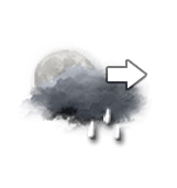
Tonight
19°Feels Like 18°
10 km/hGusts15 km/h
Very cloudy sky, clearing fully.
Showers spaced out over the hours.
Risk of rain
100 %
This morning
18°Feels Like 18°
CalmGusts10 km/h
Good weather with few clouds.
No precipitation.
No risk of rain
UV index5Moderate
This afternoon
32°Feels Like 36°due to the sun
CalmGusts25 km/h>90 km/h
Good clear weather becoming unsettled.
A few light showers.
Risk of rain
60 %
UV index8Very high
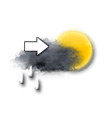
This evening
23°Feels Like 24°
10 km/hGusts50 km/h>85 km/h
Decreasing thunderstorm activity.
A few showers.
Risk of rain
90 %
UV index2Low
Night
19°Feels Like 18°
10 km/hGusts35 km/h>75 km/h
Long clear periods, with a risk of changing to thundery weather.
Risk of showers.
Risk of rain
40 %
Share
CLIMATE info
Rain
-60%
normal
Less rain than normal
Water restriction: Emergency
Temperature
+5°C
normal
Warmer than normal
Normal temperature : 20°C
Average, today :
25°C
One year ago : 19°C