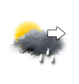
This afternoon in Val d'Ese, Cloudy spells, sometimes dense. Light showers.
Temperatures will vary between 15 and 24°C.
The reliability of the situation is particularly poor.
15:00 to 18:00
23°Feels Like 23°
15 km/hGusts30 km/h
Sunny periods and passing clouds, sometimes heavy.
A few light showers.
Risk of rain
65 %
UV index5Moderate
Freezing level 0°
4150 m
Snow-rain limit
3850 m
Snow expected
0 cm
This evening
17°Feels Like 17°
CalmGusts20 km/h
Unsettled weather becoming clear.
Heavy showers clearing later.
Risk of rain
95 %
UV index2Low
Freezing level 0°
4200 m
Snow-rain limit
3900 m
Snow expected
0 cm
Night
14°Feels Like 13°
CalmGusts15 km/h
Clear sky.
No precipitation.
No risk of rain
Freezing level 0°
4100 m
Snow-rain limit
3800 m
Snow expected
0 cm
Share
CLIMATE info
Rain
-85%
normal
Less rain than normal
Water restriction: Watch
Temperature
+2°C
normal
Warmer than normal
Normal temperature : 18°C
Average, today :
20°C
One year ago : 23°C