Today in Col du Pison, rain and snow will affect the region in the second half of the day.
Temperatures will vary between 0 and 4°C, it will be cold and with values close to normal.
The reliability of the situation is relatively good.
9:00 to 12:00
2°Feels Like 3°
Gusts 30 km/hSW 10 km/h
Scattered clouds, but also several good sunny periods.
Slight risk of showers.
Risk of rain
25 %
UV index1Low
This afternoon
4°Feels Like 4°
Gusts 30 km/hSW 15 km/h
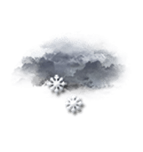
Overcast and misty. Limited visibility.
Snow showers starting to fall at the end of the afternoon.
Risk of snow
50 %
UV index1Low
This evening
1°Feels Like 0°
Gusts 35 km/hW 10 km/h
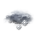
Overcast and misty. Limited visibility.
Snow showers.
Risk of snow
90 %
Night
0°Feels Like -3°due to the wind
Gusts 50 km/hN 20 km/h
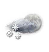
Very cloudy sky with short clear periods.
Snow showers.
Risk of snow
85 %
Share
CLIMATE info
Rain
+110%
normal
More rain than normal
Water restriction: No restrictions
Temperature
0°C
normal
Temperature near normal
Normal temperature : 2°C
Average, today :
2°C
One year ago : 5°C